A truck driver discovering at 2 AM that the only road to the delivery point has a 3.5 t weight limit, or that the entire region is closed for HGV transit until Monday morning, is every dispatcher's nightmare. Most of these situations are not random bad luck. They are knowable in advance, but only if your routing engine understands what a truck actually is.
Consumer navigation apps treat your 40-tonne combination the same as a hatchback. Transport Nomad does not. This guide walks through the truck-specific constraints European routes are full of, and how Transport Nomad uses your vehicle profile to plan around them automatically.
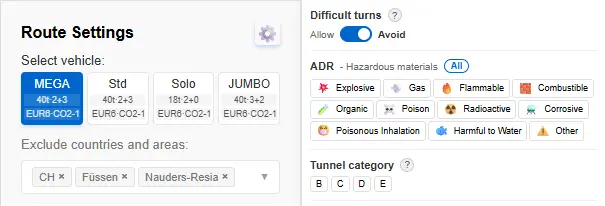
Step 1: enter your vehicle parameters once
Every routing decision Transport Nomad makes starts from the vehicle profile. Once you tell the system what your truck is, every route you plan is filtered to roads it can legally and physically travel.
The parameters that drive routing:
- Gross weight (GVW). Used against weight-limited roads and bridges.
- Height. Used against low bridges and tunnel clearances.
- Width and length. Used against narrow streets and overall vehicle envelope rules.
- Number of axles. Relevant for both restrictions and toll rates.
- ADR class and tunnel category. Covered separately below.
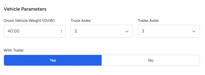
Once set, Transport Nomad will only route your truck along roads cleared for those parameters. A 4-metre-high vehicle will never be sent under a 3.8 m bridge. A 40-tonne combination will not be routed onto a 7.5 t-limited residential street.
Step 2: area restrictions, not just road signs
A common mistake in route planning is thinking of restrictions as something tied to individual roads. In reality a large share of European HGV restrictions cover entire regions for specific time windows:
- Sunday and public holiday bans in Germany, Austria, France, Italy, Switzerland, Poland, and others.
- Summer weekend bans in France and Italy along tourist corridors.
- Night driving bans in Austria and parts of Switzerland.
- Low-emission zones (Umweltzonen, ZTL, ZFE) in city centres.
Transport Nomad renders these areas directly on the map as coloured zones, so you can see at a glance which countries or regions block transit at the time you are planning to drive through. If the plan crosses a Sunday ban, you can shift the departure window before the truck even leaves the yard.
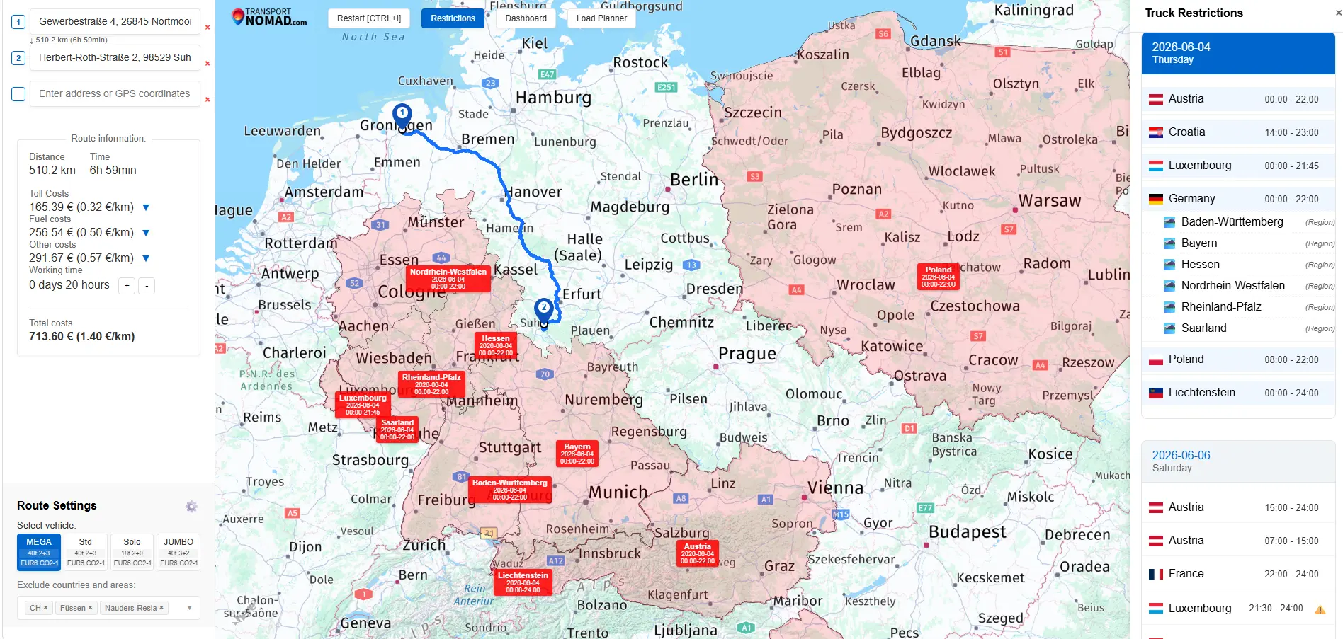
This is the same data a dispatcher would otherwise have to look up across a dozen national transport ministry websites, each in a different language and update cadence.
Step 3: warnings when the last mile is restricted
Sometimes the destination itself sits inside a restricted zone. A warehouse on a 12 t-limited industrial estate, an unloading dock behind a low bridge, a customer in the historic centre of an Italian town. Transport Nomad still has to deliver you to that exact point, so the routing engine finds the best legal path it can, but it does not silently pretend the restriction is not there.
When part of the route can only be completed through a restricted segment, that segment is drawn in red on the map and flagged with a warning panel. The dispatcher sees explicitly: "the last 800 metres of this route cross a 7.5 t weight limit."
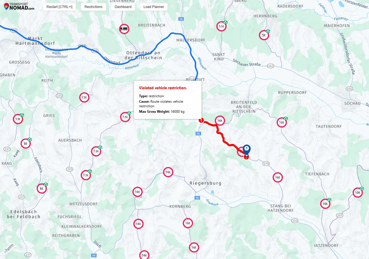
The decision then becomes a human one: call the consignee to arrange a permit, swap to a lighter vehicle, transhipment, or simply accept the risk knowingly. What matters is that the dispatcher knows, before the truck arrives.
Step 4: manually excluding tricky areas
Some restrictions do not show up on official road signs at all. They come from local enforcement practice, customer agreements, recent incidents, or simply experience that says "trucks don't go through there." Two examples from common European haulage practice:
- The Füssen / Reutte corridor, where Austria has tightened transit enforcement and German hauliers are increasingly turned back or fined.
- Excluding an entire country, such as Switzerland. A common practice in European haulage when a carrier deliberately avoids a country because of high road charges, extra customs formalities, or specific regulatory burdens.
These areas may be technically passable for your vehicle. The routing engine, going by infrastructure data alone, will happily send you through them. To prevent that, Transport Nomad lets you draw exclusion zones directly on the map. Any route planned afterwards will detour around the zone, even if the detour is longer.
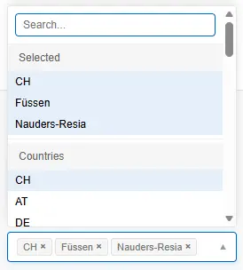
Exclusion zones persist for your team, so once a senior dispatcher marks a problem area, every junior planner benefits from that institutional knowledge automatically.
Step 5: ADR-aware routing
For dangerous goods transport, the rules change completely. The relevant route is not the shortest or the fastest, it is the one that respects:
- The ADR class of the cargo (1 through 9, with subdivisions).
- The tunnel restriction category assigned to each tunnel (A through E).
- National route designations for hazardous goods movements.
You set the ADR class and the tunnel category on the vehicle or the trip, and Transport Nomad replans accordingly. Routes that would normally take you through, say, the Gotthard road tunnel on a class D-restricted load are rerouted around it. Country-specific ADR-mandated routings are honoured where they apply.
This is one of the features that genuinely saves money. An ADR misroute that ends with the truck turned away at a tunnel mouth costs hours and often a fine.
Step 6: avoiding difficult turns and tight bends
Not every problem on the road is a hard legal restriction. Some are just hard. Tight switchbacks on Alpine passes, narrow turning radii in old town centres, hairpin bends on rural connecting roads. A 16.5 m articulated combination physically struggles where the law does not formally object.
Transport Nomad lets you tell the router: prefer to avoid difficult turns. When this option is on, the engine takes a slight detour wherever a longer but easier path exists. When no such alternative is reasonable, it still routes through the difficult section, but flags it on the map so the driver gets a heads-up before they arrive.
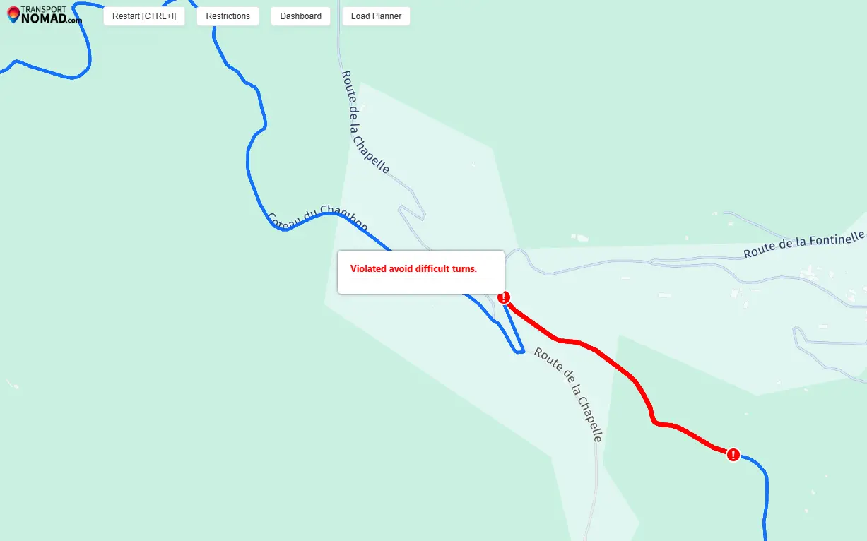
The combination of "avoid where possible, warn where unavoidable" is what experienced dispatchers want. A pure "avoid at all costs" option would push routes onto absurd 200 km detours every time a hairpin appears. A pure "ignore" option would keep sending new drivers into trouble.
Why this matters for your rates
All of this routing intelligence has a direct commercial consequence: the kilometre count you see in Transport Nomad is the kilometre count the truck will actually drive.
When the engine routes around a 7.5 t weight limit, around a Sunday ban region, around an ADR-restricted tunnel, around your manually excluded Füssen corridor, those detours are baked into the distance shown on the route. A naive consumer-grade map would have planned the shortest line, given you 1 180 km, and then the driver would have rerouted in the cab and actually covered 1 260 km. The €/km rate you quoted the customer was right; the kilometres you quoted were wrong, and the margin walked out the door.
Real kilometres in planning means accurate cost-per-kilometre calculations, accurate fuel projections, accurate driver-time estimates, and quotes that match the invoice at the end of the month. It is the difference between "we hope this trip is profitable" and "we know what this trip costs before the truck moves."
Summary
The point of truck-specific routing is not to remove human judgement, it is to make sure the dispatcher and the driver are working off the same set of facts as the road network actually presents. Vehicle profile filters out roads the truck cannot use. Area overlays surface time-based bans. Red warning segments make exceptions explicit. Manual exclusion zones encode local knowledge. ADR class drives hazardous goods routing. Difficult-turn avoidance handles what physics, not legislation, makes hard.
Set up your trucks once, draw a few exclusion zones for known problem areas, and every route after that benefits from the full picture.